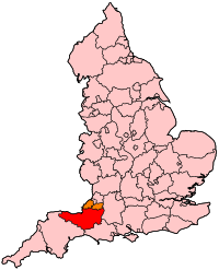
파일:EnglandSomerset.svg

SVG 파일의 PNG 형식의 미리보기 크기: 200 × 247 픽셀. 다른 해상도: 194 × 240 픽셀 | 389 × 480 픽셀 | 622 × 768 픽셀 | 829 × 1,024 픽셀 | 1,658 × 2,048 픽셀
원본 파일 (SVG 파일, 실제 크기 200 × 247 픽셀, 파일 크기: 232 KB)
파일 역사
날짜/시간 링크를 클릭하면 해당 시간의 파일을 볼 수 있습니다.
| 날짜/시간 | 섬네일 | 크기 | 사용자 | 설명 | |
|---|---|---|---|---|---|
| 현재 | 2007년 4월 23일 (월) 05:43 |  | 200 × 247 (232 KB) | Wereon | Map of Somerset within England. Category:Maps of counties of England |
이 파일을 사용하는 문서
다음 문서 1개가 이 파일을 사용하고 있습니다:
이 파일을 사용하고 있는 모든 위키의 문서 목록
다음 위키에서 이 파일을 사용하고 있습니다:
- bg.wiki.x.io에서 이 파일을 사용하고 있는 문서 목록
- br.wiki.x.io에서 이 파일을 사용하고 있는 문서 목록
- cy.wiki.x.io에서 이 파일을 사용하고 있는 문서 목록
- da.wiki.x.io에서 이 파일을 사용하고 있는 문서 목록
- en.wiki.x.io에서 이 파일을 사용하고 있는 문서 목록
- Category:Towns in Somerset
- Category:Schools in Somerset
- Taunton (UK Parliament constituency)
- Somerton and Frome (UK Parliament constituency)
- Wells (UK Parliament constituency)
- Yeovil (UK Parliament constituency)
- Geology of Somerset
- Bridgwater and West Somerset (UK Parliament constituency)
- Taunton Deane (UK Parliament constituency)
- Category:Wikipedia requested photographs in Somerset
- Portal:Somerset
- Portal:Somerset/Intro
- Transport in Somerset
- fr.wiki.x.io에서 이 파일을 사용하고 있는 문서 목록
- Bedford (circonscription britannique)
- Thornbury and Yate (circonscription britannique)
- Torridge and West Devon
- Torbay (circonscription britannique)
- Stroud (circonscription britannique)
- Tewkesbury (circonscription britannique)
- The Cotswolds (circonscription britannique)
- Bridgwater and West Somerset (circonscription britannique)
- Somerton and Frome (circonscription britannique)
- Taunton Deane (circonscription britannique)
- Wells (circonscription britannique)
- Catégorie:Film tourné dans le Somerset
- oc.wiki.x.io에서 이 파일을 사용하고 있는 문서 목록
- pl.wiki.x.io에서 이 파일을 사용하고 있는 문서 목록
- sco.wiki.x.io에서 이 파일을 사용하고 있는 문서 목록
- zh-min-nan.wiki.x.io에서 이 파일을 사용하고 있는 문서 목록