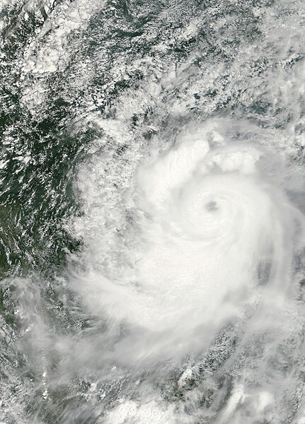
파일:Mindulle aug 24 2010.jpg

미리 보기 크기: 431 × 600 픽셀 다른 해상도: 172 × 240 픽셀 | 345 × 480 픽셀 | 552 × 768 픽셀 | 736 × 1,024 픽셀 | 1,472 × 2,048 픽셀 | 4,600 × 6,400 픽셀
원본 파일 (4,600 × 6,400 픽셀, 파일 크기: 4.79 MB, MIME 종류: image/jpeg)
파일 역사
날짜/시간 링크를 클릭하면 해당 시간의 파일을 볼 수 있습니다.
| 날짜/시간 | 섬네일 | 크기 | 사용자 | 설명 | |
|---|---|---|---|---|---|
| 현재 | 2020년 10월 19일 (월) 01:58 |  | 4,600 × 6,400 (4.79 MB) | FleurDeOdile | dimensions |
| 2010년 8월 29일 (일) 14:31 |  | 3,708 × 3,184 (5.86 MB) | Supportstorm | {{Information |Description={{en|1=Tropical Storm Mindulle made landfall along the coast of Vietnam shortly after forming in late August 2010. On the mornings of August 24 and 25, Minduelle caused flooding in multiple provinces, according to a bulletin fro |
이 파일을 사용하는 문서
다음 문서 1개가 이 파일을 사용하고 있습니다:
이 파일을 사용하고 있는 모든 위키의 문서 목록
다음 위키에서 이 파일을 사용하고 있습니다:
- de.wiki.x.io에서 이 파일을 사용하고 있는 문서 목록
- en.wiki.x.io에서 이 파일을 사용하고 있는 문서 목록
- ja.wiki.x.io에서 이 파일을 사용하고 있는 문서 목록
- pt.wiki.x.io에서 이 파일을 사용하고 있는 문서 목록
- th.wiki.x.io에서 이 파일을 사용하고 있는 문서 목록
- vi.wiki.x.io에서 이 파일을 사용하고 있는 문서 목록
- www.wikidata.org에서 이 파일을 사용하고 있는 문서 목록
- zh.wiki.x.io에서 이 파일을 사용하고 있는 문서 목록

