파일:Sanguie departments.png

미리 보기 크기: 776 × 600 픽셀 다른 해상도: 311 × 240 픽셀 | 621 × 480 픽셀 | 994 × 768 픽셀 | 1,056 × 816 픽셀
원본 파일 (1,056 × 816 픽셀, 파일 크기: 46 KB, MIME 종류: image/png)
파일 설명
| 설명 |
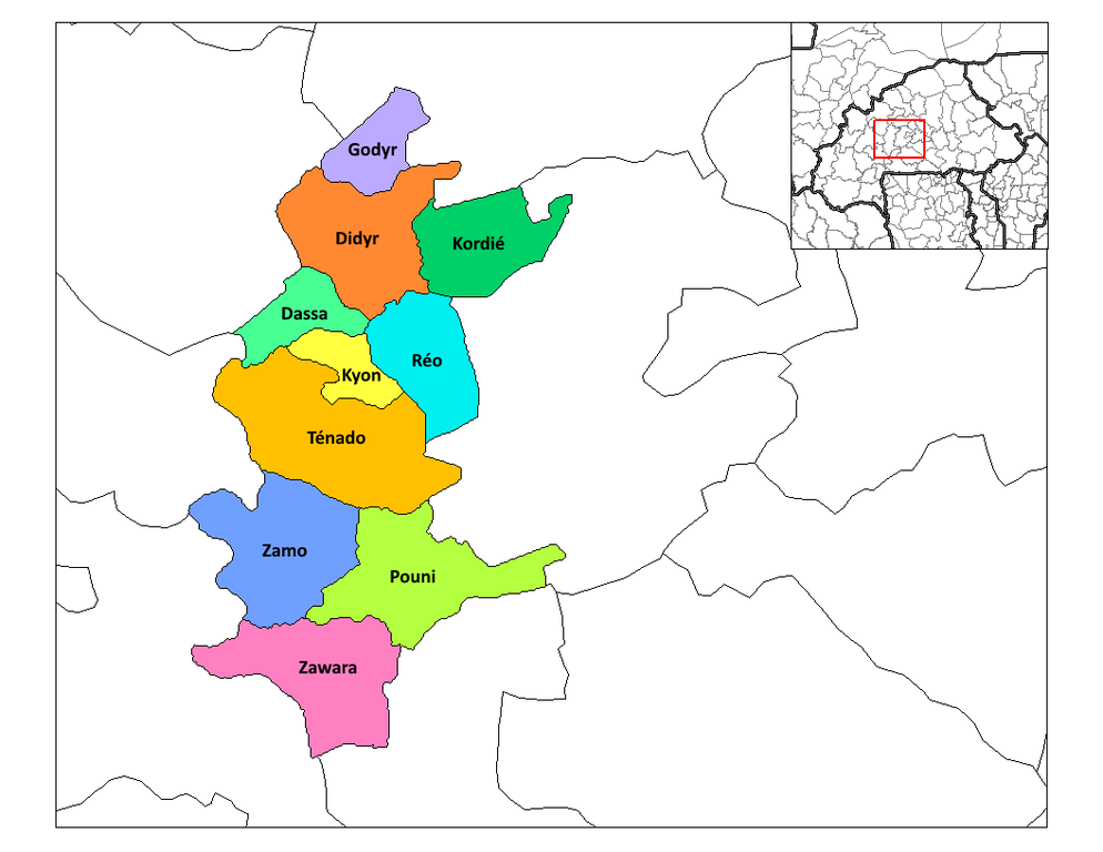
This map has been uploaded by Osiris fancy from en.wiki.x.io to enable the Wikimedia Atlas of the World. Original uploader to en.wiki.x.io was Rarelibra. Osiris fancy is not the creator of this map. Licensing information is below. Map of the departments of Sanguie province in Burkina Faso. Created by Rarelibra 03:34, 30 September 2006 (UTC) for public domain use, using MapInfo Professional v8.5 and various mapping resources. |
| 날짜 | 2007년 3월 11일 (원본 올리기 일시) |
| 출처 | No machine-readable source provided. Own work assumed (based on copyright claims). |
| 저자 | No machine-readable author provided. Osiris fancy assumed (based on copyright claims). |
라이선스
| 나는 이 작품의 저작권자로서, 이 작품을 퍼블릭 도메인으로 모두에게 공개합니다. 이 공개 선언은 전 세계적으로 유효합니다. 만약 저작권의 포기가 법률적으로 가능하지 않은 경우, 나는 이 작품을 법적으로 허용되는 한도 내에서 누구나 자유롭게 어떤 목적으로도 제한없이 사용할 수 있도록 허용합니다. |
파일 역사
날짜/시간 링크를 클릭하면 해당 시간의 파일을 볼 수 있습니다.
| 날짜/시간 | 섬네일 | 크기 | 사용자 | 설명 | |
|---|---|---|---|---|---|
| 현재 | 2022년 1월 6일 (목) 15:23 | | 1,056 × 816 (46 KB) | Verdy p | Add a missing departement; fix names |
| 2007년 3월 12일 (월) 01:35 |  | 1,056 × 816 (32 KB) | Osiris fancy | This map has been uploaded by Osiris fancy from en.wiki.x.io to enable the Wikimedia Atlas of the World. Original uploader to en.wiki.x.io was Rarelibra. Osiris fancy is not the creator of this map. Licensing information is |
이 파일을 사용하는 문서
다음 문서 1개가 이 파일을 사용하고 있습니다:
이 파일을 사용하고 있는 모든 위키의 문서 목록
다음 위키에서 이 파일을 사용하고 있습니다:
- cs.wiki.x.io에서 이 파일을 사용하고 있는 문서 목록
- en.wiki.x.io에서 이 파일을 사용하고 있는 문서 목록
- Departments of Burkina Faso
- Sanguié Province
- User talk:Rarelibra/Maps1
- Wikipedia:WikiProject Burkina Faso/Provincial templates
- Template:Sanguié
- Dassa Department
- Didyr Department
- Godyr Department
- Kyon Department
- Kordie Department
- Pouni Department
- Réo Department
- Zawara Department
- Ténado Department
- Zamo (department)
- User:GerardM/Departments of Burkina Faso
- es.wiki.x.io에서 이 파일을 사용하고 있는 문서 목록
- fr.wiki.x.io에서 이 파일을 사용하고 있는 문서 목록
- ha.wiki.x.io에서 이 파일을 사용하고 있는 문서 목록
- id.wiki.x.io에서 이 파일을 사용하고 있는 문서 목록
- ig.wiki.x.io에서 이 파일을 사용하고 있는 문서 목록
- it.wiki.x.io에서 이 파일을 사용하고 있는 문서 목록
- ja.wiki.x.io에서 이 파일을 사용하고 있는 문서 목록
- nl.wiki.x.io에서 이 파일을 사용하고 있는 문서 목록
- pt.wiki.x.io에서 이 파일을 사용하고 있는 문서 목록
- sw.wiki.x.io에서 이 파일을 사용하고 있는 문서 목록
- ts.wiki.x.io에서 이 파일을 사용하고 있는 문서 목록
- tum.wiki.x.io에서 이 파일을 사용하고 있는 문서 목록
- uk.wiki.x.io에서 이 파일을 사용하고 있는 문서 목록
- ur.wiki.x.io에서 이 파일을 사용하고 있는 문서 목록
- vi.wiki.x.io에서 이 파일을 사용하고 있는 문서 목록
이 파일의 더 많은 사용 내역을 봅니다.