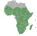
파일:Sub-Saharan Africa definition UN.png
Sub-Saharan_Africa_definition_UN.png (362 × 340 픽셀, 파일 크기: 6 KB, MIME 종류: image/png)
파일 역사
날짜/시간 링크를 클릭하면 해당 시간의 파일을 볼 수 있습니다.
| 날짜/시간 | 섬네일 | 크기 | 사용자 | 설명 | |
|---|---|---|---|---|---|
| 현재 | 2013년 7월 20일 (토) 05:47 |  | 362 × 340 (6 KB) | Maproom | Reshaded South Sudan, which the UN now regards as in East Africa, not North Africa: see http://unstats.un.org/unsd/methods/m49/m49regin.htm |
| 2012년 4월 12일 (목) 22:27 |  | 362 × 340 (9 KB) | Hazhk | Adding different shading for Sudan & S. Sudan because they're also classified as being part of North Africa by the UN | |
| 2011년 7월 10일 (일) 07:02 |  | 356 × 344 (11 KB) | Maphobbyist | South Sudan has become independent on July 9, 2011. Sudan and South Sudan are shown with the new international border between them. | |
| 2011년 3월 31일 (목) 15:46 |  | 356 × 344 (10 KB) | Hoshie | added Cabinda (Angola) to map | |
| 2010년 12월 15일 (수) 20:18 |  | 356 × 344 (6 KB) | Jcherlet | {{Information |Description=Definition of Sub-Saharan Africa, according to the United Nations institutions |Source=*File:HDImap_spectrum2006_Africa.png |Date=2010-12-15 11:13 (UTC) |Author=*Jcherlet: '''Jcherlet''' *derivative work: |
이 파일을 사용하는 문서
다음 문서 1개가 이 파일을 사용하고 있습니다:
이 파일을 사용하고 있는 모든 위키의 문서 목록
다음 위키에서 이 파일을 사용하고 있습니다:
- ast.wiki.x.io에서 이 파일을 사용하고 있는 문서 목록
- ca.wiki.x.io에서 이 파일을 사용하고 있는 문서 목록
- ckb.wiki.x.io에서 이 파일을 사용하고 있는 문서 목록
- cs.wiki.x.io에서 이 파일을 사용하고 있는 문서 목록
- de.wiki.x.io에서 이 파일을 사용하고 있는 문서 목록
- en.wiki.x.io에서 이 파일을 사용하고 있는 문서 목록
- Sub-Saharan Africa
- Water supply and sanitation in sub-Saharan Africa
- Wikipedia:Reference desk/Archives/Humanities/2013 October 5
- Category:Birds of Sub-Saharan Africa
- Category:Fauna of Sub-Saharan Africa
- Category:Biota of Sub-Saharan Africa
- Category:Mammals of Sub-Saharan Africa
- User:DexDor/Categorization of organisms by geography
- Category:Moths of Sub-Saharan Africa
- Category:Amphibians of Sub-Saharan Africa
- et.wiki.x.io에서 이 파일을 사용하고 있는 문서 목록
- ha.wiki.x.io에서 이 파일을 사용하고 있는 문서 목록
- he.wiki.x.io에서 이 파일을 사용하고 있는 문서 목록
- id.wiki.x.io에서 이 파일을 사용하고 있는 문서 목록
- ig.wiki.x.io에서 이 파일을 사용하고 있는 문서 목록
- ilo.wiki.x.io에서 이 파일을 사용하고 있는 문서 목록
- it.wiki.x.io에서 이 파일을 사용하고 있는 문서 목록
- ja.wiki.x.io에서 이 파일을 사용하고 있는 문서 목록
- ka.wiki.x.io에서 이 파일을 사용하고 있는 문서 목록
- lt.wiki.x.io에서 이 파일을 사용하고 있는 문서 목록
- pa.wiki.x.io에서 이 파일을 사용하고 있는 문서 목록
- pnb.wiki.x.io에서 이 파일을 사용하고 있는 문서 목록
- ro.wiki.x.io에서 이 파일을 사용하고 있는 문서 목록
- simple.wiki.x.io에서 이 파일을 사용하고 있는 문서 목록
- sr.wiki.x.io에서 이 파일을 사용하고 있는 문서 목록
- sv.wiki.x.io에서 이 파일을 사용하고 있는 문서 목록
- ta.wiki.x.io에서 이 파일을 사용하고 있는 문서 목록
- th.wiki.x.io에서 이 파일을 사용하고 있는 문서 목록
- tn.wiki.x.io에서 이 파일을 사용하고 있는 문서 목록
- tr.wiki.x.io에서 이 파일을 사용하고 있는 문서 목록
- ur.wiki.x.io에서 이 파일을 사용하고 있는 문서 목록
이 파일의 더 많은 사용 내역을 봅니다.

