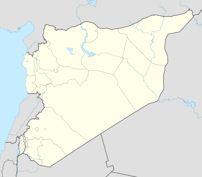
파일:Syria location map3.svg

SVG 파일의 PNG 형식의 미리보기 크기: 685 × 600 픽셀. 다른 해상도: 274 × 240 픽셀 | 548 × 480 픽셀 | 878 × 768 픽셀 | 1,170 × 1,024 픽셀 | 2,340 × 2,048 픽셀 | 922 × 807 픽셀
원본 파일 (SVG 파일, 실제 크기 922 × 807 픽셀, 파일 크기: 288 KB)
파일 역사
날짜/시간 링크를 클릭하면 해당 시간의 파일을 볼 수 있습니다.
| 날짜/시간 | 섬네일 | 크기 | 사용자 | 설명 | |
|---|---|---|---|---|---|
| 현재 | 2022년 11월 18일 (금) 23:07 |  | 922 × 807 (288 KB) | GrandEscogriffe | more correct N/S stretching |
| 2016년 2월 20일 (토) 00:55 |  | 922 × 762 (280 KB) | Deuar | Fixing bug (bogus grey line). Thank you to Kordestani for pointing it out. | |
| 2016년 2월 19일 (금) 06:09 |  | 922 × 762 (288 KB) | Deuar | nope, there was still a small issue with a lake | |
| 2016년 2월 19일 (금) 06:06 |  | 922 × 762 (280 KB) | Deuar | edits: Eastern Syria details of borders, rivers, etc. That's the last of it for this series of edits I hope. | |
| 2016년 2월 13일 (토) 03:23 |  | 922 × 762 (232 KB) | Deuar | minor fix - there was an accidental shift of lakes introduced | |
| 2016년 2월 8일 (월) 10:13 |  | 922 × 762 (224 KB) | Deuar | rectifying details in southern Syria and Golan | |
| 2016년 1월 31일 (일) 01:35 |  | 922 × 762 (199 KB) | Deuar | more rectyfying details - north of Damascus and east of Aleppo. Marked Lake Jabbul and Otaybah as intermittent. Lake Otaybah is smaller, too. | |
| 2016년 1월 28일 (목) 23:27 |  | 922 × 762 (197 KB) | Deuar | Brought back hashed Golan as per consensus (sorry for missing that), combined with the more precise lines of the version of 15:10, 27 January 2016. Also: saved as plain SVG instead of Inkscape SVG. | |
| 2016년 1월 28일 (목) 05:54 |  | 922 × 762 (166 KB) | Greyshark09 | Reverted to version as of 04:09, 18 June 2015 (UTC) | |
| 2016년 1월 28일 (목) 00:10 |  | 922 × 762 (200 KB) | Deuar | Correcting details: Hama region and al-Ghab plain |
이 파일을 사용하는 문서
다음 문서 1개가 이 파일을 사용하고 있습니다:
이 파일을 사용하고 있는 모든 위키의 문서 목록
다음 위키에서 이 파일을 사용하고 있습니다:
- ace.wiki.x.io에서 이 파일을 사용하고 있는 문서 목록
- af.wiki.x.io에서 이 파일을 사용하고 있는 문서 목록
- am.wiki.x.io에서 이 파일을 사용하고 있는 문서 목록
- ar.wiki.x.io에서 이 파일을 사용하고 있는 문서 목록
- بوابة:سوريا
- قالب:خريطة مواقع سوريا
- قاعدة تفتناز الجوية العسكرية
- بوابة:سوريا/مواقع سياحية/أرشيف
- بوابة:سوريا/مواقع سياحية/1
- بوابة:سوريا/مواقع سياحية/8
- بوابة:سوريا/مواقع سياحية/26
- بوابة:سوريا/مواقع سياحية/21
- بوابة:سوريا/مواقع سياحية/18
- بوابة:سوريا/مواقع سياحية
- ابن قاضي الجبل
- البو سرايا
- تفجيرات فبراير 2013 في دمشق
- arz.wiki.x.io에서 이 파일을 사용하고 있는 문서 목록
- av.wiki.x.io에서 이 파일을 사용하고 있는 문서 목록
- azb.wiki.x.io에서 이 파일을 사용하고 있는 문서 목록
- az.wiki.x.io에서 이 파일을 사용하고 있는 문서 목록
- ba.wiki.x.io에서 이 파일을 사용하고 있는 문서 목록
- be-tarask.wiki.x.io에서 이 파일을 사용하고 있는 문서 목록
- be.wiki.x.io에서 이 파일을 사용하고 있는 문서 목록
이 파일의 더 많은 사용 내역을 봅니다.


