안데스 산맥
편집| 안데스 산맥 (케추아어족: 안티 수유) | |
| (지리 유형: 산맥) | |
 | |
| 나라 | |
|---|---|
| 도시 | 라파스 · 마니살레스 · 메데인 · 메리다 · 멘도사 · 보고타 · 부카라망가 · 산티아고 · 살타 · 수크레 · 아레키파 · 이바게 · 칼리 · 코차밤바 · 쿠스코 · 쿠엥카 · 쿠쿠타 · 키토 · 파스토 · 페레이라 |
| 최고점 | 아콩카과 산 |
| - 위치 | 아르헨티나와 칠레의 접경 |
| - 높이 | 6,962 m (22,841 ft) |
| - 좌표 | 남위 32° 39′ 10″ 서경 70° 0′ 40″ / 남위 32.65278° 서경 70.01111° |
| 길이 | 7,000 km (4,350 mi) |
| 폭 | 500 km (311 mi) |
배우는사람/틀:지역 둘러보기/문서:안데스 산맥(칠레)
배우는사람/틀:지역 둘러보기/문서:안데스 산맥(아메리카)
배우는사람/틀:지역 둘러보기/문서:안데스 산맥(지구) | |


.svg)
한영병기판
편집| Andes (케추아어족(Quechua): Anti(s/kuna)(Anti(s/kuna))) | |
| Range | |
| | |
| 나라 | Argentina · Bolivia · Chile · Colombia · Ecuador · Peru · Venezuela |
|---|---|
| 도시 | 보고타(Bogotá) · 산티아고(Santiago) · 메데인(Medellín) · La Paz|라파스(La Paz) · Cali|칼리(Cali) · 키토(Quito) · Pasto(Pasto) · Bucaramanga(Bucaramanga) · 아레키파(Arequipa) · 멘도사(Mendoza) · Cuenca|쿠엥카(Cuenca) · 코차밤바(Cochabamba) · 페레이라(Pereira) · Ibagué(Ibagué) · 살타(Salta) · Manizales(Manizales) · Cucúta(Cucúta) · 쿠스코(Cusco) · 메리다 (베네수엘라)(Mérida) · 수크레(Sucre) |
| 최고점 | Mt. 아콩카과 산(Aconcagua) |
| - 위치 | on the 아르헨티나(Argentina)-칠레(Chile) border |
| - 높이 | 6,962 m (22,841 ft) |
| - 좌표 | 남위 32° 39′ 10″ 서경 70° 0′ 40″ / 남위 32.65278° 서경 70.01111° |
| 길이 | 7,000 km (4,350 mi) |
| 폭 | 500 km (311 mi) |
 Composite satellite image of the southern Andes
| |
The Andes are the world's longest 대륙 지각(continental) 산맥(mountain range). It is a continual range of highlands along the western coast of 남아메리카(South America). This range is about 7,000 km (4,300 mi) long, about 200 km (120 mi) to 700 km (430 mi) wide (widest between 18 도 (각도)(degree)s South and 20 degrees South 위도(latitude)), and of an average height of about 4,000 m (13,000 ft).
Along their length, the Andes are split into several ranges, which are separated by intermediate depression(depression)s. The Andes are the location of several high plateaus – some of which are the locations of major 도시(cities) such as 키토(Quito), 보고타(Bogotá), 산티아고 (칠레)(Santiago de Chile), 메데인(Medellín), 수크레(Sucre), and 라파스(La Paz).
The so-called Altiplano plateau(Altiplano plateau) is probably the second-highest plateau following the Tibetan plateau(Tibetan plateau). The Andes extend to seven countries, in alphabetical order: 아르헨티나(Argentina), 볼리비아(Bolivia), 칠레(Chile), 콜롬비아(Colombia), 에콰도르(Ecuador), 페루(Peru), and 베네수엘라(Venezuela), some of which are known as the Andean States(Andean States).
The Andes range is the world's highest mountain range outside of the 대륙(continent) of 아시아(Asia). Their highest peak, Mt. 아콩카과 산(Aconcagua), rises to an elevation of about 6,962 m (22,841 ft) above 해수면(sea level). The peak(peak) of 침보라소 산(Mt. Chimborazo) in the Ecuadorean Andes is located the point on the surface of the Earth that is the most distant one from its center. This is because of the Earth's equatorial bulge(equatorial bulge) that results from its rapid rotation (far faster than those of 금성(Venus), 머큐리(Mercury), the 달(Moon), 가니메데(Ganymede), 티탄(Titan), or 트리톤(Triton)). The world's highest volcanos are in the Andes, including 오호스델살라도 산(Ojos del Salado) on the Chile-Argentina frontier which rises to 6,893 m (22,615 ft), and over 50 other volcanos that rise above 6,000 m.
Name
편집The etymology of the word Andes has been debated. The major consensus is that it derives from the 케추아어족(Quechua) word anti, which means "high crest". Others believe that Andes comes Anti Suyu(Anti Suyu), one of the four regions of the Inca empire. It is more likely however that the word Antisuyo derives from the use of Anti to designate mountain chains. Derivation from the 스페인어(Spanish) andén (in the sense of cultivation 계단식 논(terrace)) has also been proposed, yet considered very unlikely.
Geography
편집
The Andes can be divided into three sections:
I. The Southern Andes in Argentina and Chile;
II. The Central Andes, including the Chilean and Peruvian cordilleras and parts of Bolivia;
III. The Northern Andes in Venezuela, Colombia, and Ecuador that consist of two parallel ranges, the Cordillera Occidental and the Cordillera Oriental. In Colombia, south its the border with Ecuador, the Andes split in three parallel ranges, the western, central, and eastern ranges. (The cordillera occidental, central, and oriental).
In the northern part of the Andes, the isolated Sierra Nevada de Santa Marta(Sierra Nevada de Santa Marta) range is often considered to be part of the Andes. The eastern range of Colombia is the only one that extends to Venezuela.[1] The term cordillera comes from the Spanish word meaning "rope", because Spain does not possess any large mountain ranges. The Andes range is about 200 킬로미터 (124 마일) wide throughout its length, except in the Bolivian flexure where it is about 640 킬로미터 (398 마일) wide. The islands of the Dutch Caribbean 아루바(Aruba), 보네르 섬(Bonaire), and 퀴라소 섬(Curaçao), which lie in the 카리브 해(Caribbean Sea) off the coast of Venezuela, represent the submerged peaks of the extreme northern edge of the Andes range.
Geology
편집틀:Geology of the Andes 틀:Expand The Andes are a 중생대(Mesozoic) – 제3기(Tertiary) orogenic(orogenic) belt of mountains along the 환태평양 조산대(Pacific Ring of Fire), a zone of volcanic activity(volcanic activity) that encompasses the Pacific rim of the Americas as well as the 아시아 태평양(Asia-Pacific) region. The Andes are the result of 판 구조론(plate tectonics) processes, caused by the 섭입(subduction) of 해양 지각(oceanic crust) beneath the South American plate(South American plate). The main cause of the rise of the Andes is the compression of western rim of the 남아메리카판(South American Plate) due to the subduction of the 나스카판(Nazca Plate) and the 남극판(Antarctic Plate). To the east, the Andes are bounded by several 퇴적 분지(sedimentary basin)s such as 오리노코 강(Orinoco), Amazon Basin(Amazon Basin), Madre de Dios(Madre de Dios) and 그란차코(Gran Chaco) which separates the Andes from the ancient craton(craton)s in eastern South America. In the south the Andes shares a long boundary with the former 파타고니아(Patagonia Terrane). To the west the Andes ends at the 태평양(Pacific Ocean), although the Peru-Chile trench(Peru-Chile trench) can be considerated its ultimate western limit. From a geographical approach the Andes are considered to have their western boundaries marked by the appearance of coastal lowlands and a less rugged topography.
Orogeny
편집The western rim of the 남아메리카판(South American Plate) has been the place of several pre-Andean orogenies since at least the of the late 원생누대(Proterozoic) and early 고생대(Paleozoic) when several terrane(terrane)s and microcontinent(microcontinent)s collided and amalgamated with the ancient craton(craton)s of eastern South America, by then the 남아메리카판(South American part) of 곤드와나(Gondwana).
The formation of the modern Andes began with the events of the 트라이아스기(Triassic) when Pangea begun to break up and several rift(rift)s developed. It continued through the 쥐라기(Jurassic) Period. It was during the 백악기(Cretaceous) Period that the Andes began to take their present form, by the uplifting(uplifting), 단층(faulting) and 습곡(folding) of sedimentary(sedimentary) and metamorphic rocks(metamorphic rocks) of the ancient craton(craton)s to the east. The rise of the Andes has not been been constant and different regions have had different degrees of tectonic stress, uplift, and 침식(erosion).
Tectonic forces above the subduction zone(subduction zone) along the entire west coast of South America where the 나스카판(Nazca Plate) and a part of the 남극판(Antarctic Plate) are sliding beneath the 남아메리카판(South American Plate) continue to produce an ongoing 조산 운동(orogenic event) resulting in minor to major 지진(earthquake)s and volcanic eruption(volcanic eruption)s to this day. In the extreme south a major 변환 단층(transform fault) separates 티에라델푸에고 제도(Tierra del Fuego) from the small 스코티아판(Scotia Plate). Across the 1,000 km (620 mi) wide 드레이크 해협(Drake Passage) lie the mountains of the 남극 반도(Antarctic Peninsula) south of the Scotia Plate which appear to be a continuation of the Andes chain.[출처 필요]
Volcanism
편집

The Andes range has many active volcanoes, which are distributed in four volcanic zones separated by areas of inactivity. The Andean volcanism is a result of 섭입(subduction) of the 나스카판(Nazca Plate) and 남극판(Antarctic Plate) underneath the 남아메리카판(South American Plate). The belt is subdivided into four main volcanic zones that are separed from each other by volcanic gaps. The volcanoes of the belt are diverse in terms of activity style, products and morphology. While some differences can be explained by which volcanic zone a volcano belongs to, there significant differences inside volcanic zones and even between neighboring volcanoes. Despite being a type location for calc-alkalic(calc-alkalic) and subduction volcanism, the Andean Volcanic Belt has a large range of volcano-tectonic settings, such as rift systems and extrensional zones, transpressional faults, subduction of 해령(mid-ocean ridge)s and seamount(seamount) chains apart from a large range on crustal thicknesses and 마그마(magma) ascent paths, and different amount of crustal assimilations.
Ore deposits and evaporites
편집Climate and hydrology
편집

The climate in the Andes varies greatly depending on location, altitude, and proximity to the sea. The southern section is rainy and cool, the central Andes are dry. The northern Andes are typically rainy and warm, with an average temperature of 18 °C (64 °F) in Colombia. The climate is known to change drastically in rather short distances. 우림(Rainforest)s exist just miles away from the snow covered peak Cotopaxi. The mountains have a large effect on the temperatures of nearby areas. The snow line(snow line) depends on the location. It is at between 4,500–4,800 m (14,800–15,800 ft) in the tropical Ecuadorian, Colombian, Venezuelan, and northern Peruvian Andes, rising to 4,800–5,200 m (15,800–17,060 ft) in the drier mountains of southern Peru south to northern Chile south to about 30°S, then descending to 4,500 m (14,760 ft) on Aconcagua at 32°S, 2,000 m (6,600 ft) at 40°S, 500 m (1,640 ft) at 50°S, and only 300 m (980 ft) in 티에라델푸에고 제도(Tierra del Fuego) at 55°S; from 50°S, several of the larger glaciers descend to sea level.[2]
The Andes of Chile and Argentina can be divided in two climatic and glaciological zones; the Dry Andes(Dry Andes) and the Wet Andes(Wet Andes). Since the Dry Andes extends from the latitudes of 아타카마 사막(Atacama Desert) to the area of Maule River(Maule River), precipitation is more sporadical and there are strong temperature oscillations. The line of equilibrium may shift drastically over short periods of time, leaving a whole glacier in the ablation(ablation) area or in the accumulation area(accumulation area).
In the high Andes of central Chile and 멘도사 주(Mendoza Province) rock glacier(rock glacier)s are larger and more common than glaciers, this is due to the high exposure to solar radiation(solar radiation).[3]
Flora
편집Rainforests(Rainforests) used to encircle much of the northern Andes but are now greatly Deforestation(diminished), especially in the Chocó(Chocó) and inter-Andean valleys of Colombia. As a direct opposite of the humid Andean slopes are the relatively dry Andean slopes in most of western Peru, Chile and Argentina. Along with several Interandean Valles(Interandean Valles), they are typically dominated by 낙엽성(deciduous) woodland, shrub and xeric(xeric) vegetation, reaching the extreme in the slopes near the virtually lifeless Atacama Desert.
About 30,000 species of vascular plants(vascular plants) live in the Andes with roughly half being 고유종(endemic) to the region, surpassing the diversity of any other hotspot|핫스팟(hotspot).[4] The small tree Cinchona pubescens(Cinchona pubescens), a source of 퀴닌(quinine) which is used to treat 말라리아(malaria), is found widely in the Andes as far south as Bolivia. Other important crops that originated from the Andes are 담배 (식물)(tobacco) and potatoes(potatoes). The high-altitude Polylepis(Polylepis) forests and woodlands are found in the Andean areas of Colombia, Ecuador, Peru, Bolivia and Chile. These trees, by locals referred to as Queñua, Yagual and other names, can be found at altitudes of 4,500 m (14,760 ft) above sea level. It remains unclear if the patchy distribution of these forests and woodlands is natural, or the result of clearing which began during the Inca(Inca)n period. Regardless, in modern times(modern times) the clearance has accelerated, and the trees are now considered to be highly endangered(endangered), with some believing that as little as 10% of the original woodland remains.[5]
Fauna
편집

The Andes are rich in fauna: With almost 1,000 species, of which roughly 2/3 are endemic]](endemic) to the region, the Andes are the most important region in the world for amphibians(amphibians).[4] The diversity of animals in the Andes is high, with almost 600 species of mammals(mammals) (13% endemic), more than 1,700 species of birds(birds) (about 1/3 endemic), more than 600 species of reptiles(reptiles) (about 45% endemic), and almost 400 species of 물고기(fish) (about 1/3 endemic).[4]
The 비쿠냐(Vicuña) and 구아나코(Guanaco) can be found living in the Altiplano(Altiplano), while the closely related domesticated(domesticated) 라마(Llama) and 알파카(Alpaca) are widely kept by locals as pack animal(pack animal)s and for their 고기(meat) and 양모(wool). The nocturnal chinchilla(chinchilla)s, two threatened members of the 설치류(rodent) order, inhabits the Andes' alpine regions. The Andean Condor(Andean Condor), the largest bird of its kind in the 서반구(Western Hemisphere), occurs throughout much of the Andes but generally in very low densities. Other animals found in the relatively open habitats of the high Andes include the huemul(huemul), 퓨마(cougar), foxes in the genus Pseudalopex(Pseudalopex), and, for birds, certain species of 도요타조(tinamou)s (notably members of the genus Nothoprocta(Nothoprocta)), Andean Goose(Andean Goose), Giant Coot(Giant Coot), 홍학(flamingo)s (mainly associated with hypersaline(hypersaline) lakes), Lesser Rhea(Lesser Rhea), Andean Flicker(Andean Flicker), Diademed Sandpiper-plover(Diademed Sandpiper-plover), miners(miners), sierra-finches(sierra-finches) and diuca-finches(diuca-finches).
티티카카 호(Lake Titicaca) hosts several endemics, among them the highly endangered Titicaca Flightless Grebe(Titicaca Flightless Grebe) and Titicaca Water Frog(Titicaca Water Frog). A few species of hummingbirds(hummingbirds), notably some hillstars(hillstars), can be seen at altitudes above 4,000 m (13,100 ft), but far higher diversities(diversities) can be found at lower altitudes, especially in the humid Andean forests ("cloud forest(cloud forest)s") growing on slopes in Colombia, Ecuador, Peru, Bolivia and far northwestern Argentina. These forest-types, which includes the Yungas(Yungas) and parts of the Chocó, are very rich in flora and fauna, although few large mammals exists, exceptions being the threatened 산악맥(Mountain Tapir), 안경곰(Spectacled Bear) and 노랑꼬리양털원숭이(Yellow-tailed Woolly Monkey).
Birds of humid Andean forests include mountain-toucan(mountain-toucan)s, quetzal(quetzal)s and the Andean Cock-of-the-rock(Andean Cock-of-the-rock), while mixed species flock(mixed species flock)s dominated by tanagers(tanagers) and Furnariids(Furnariids) commonly are seen - in contrast to several vocal but typically 보호색(cryptic) species of wrens(wrens), tapaculo(tapaculo)s and antpitta(antpitta)s.
A number of species such as the Royal Cinclodes(Royal Cinclodes) and White-browed Tit-spinetail(White-browed Tit-spinetail) are associated with Polylepis, and consequently also threatened(threatened).
Human activity
편집이 문서는 위키백과의 편집 지침에 맞춰 다듬어야 합니다. |

The Andes mountains form a north-south axis of cultural influences. A long series of cultural development culminated in the expansion of the 잉카 문명(Inca civilization) and 잉카 문명(Inca Empire) in the central Andes during the 15th century. The Incas formed this civilization through imperialistic militarism as well as careful and meticulous governmental management.[6] The government sponsored the construction of aqueducts(aqueducts) and roads(roads) in addition to preexisting installations. Some of these constructions are still in existence today.
Devastated by European diseases to which they had no immunity(immunity), and civil wars, in 1532 the Incas were defeated by an alliance composed of tens of thousands allies from nations they had subjugated (e.g. Huancas(Huancas), Chachapoyas(Chachapoyas), Cañaris(Cañaris)) and a small army of 180 Spaniards led by 프란시스코 피사로(Francisco Pizarro). One of the few Inca sites the Spanish never found in their conquest was 마추 픽추(Machu Picchu), which lay hidden on a peak on the eastern edge of the Andes where they descend to the Amazon. The main surviving languages of the Andean peoples are those of the 케추아어족(Quechua) and 아이마라어(Aymara language) families. Woodbine Parish(Woodbine Parish) and Joseph Barclay Pentland(Joseph Barclay Pentland) surveyed a large part of the Bolivian Andes from 1826 to 1827.
In modern times, the largest Andean cities are Bogota, Colombia(Bogota, Colombia), with a population of about eight million, La Paz, Bolivia(La Paz, Bolivia), and Quito, Ecuador(Quito, Ecuador).
Transportation
편집Several major cities exist either in the Andes or in their foothills, among which are 보고타(Bogotá) and Cali, Colombia(Cali, Colombia), Quito, Ecuador(Quito, Ecuador), Mérida, Venezuela(Mérida, Venezuela), La Paz, Bolivia(La Paz, Bolivia), 산티아고 (칠레)(Santiago, Chile), and Cusco, Peru(Cusco, Peru). These and most other cities and large towns are now connected with 아스팔트 콘트리트(asphalt)-paved roads, while smaller towns are often connected by dirt roads, which may require a four-wheel-drive(four-wheel-drive) vehicle.[1]
Highway(Highway)s and railroad(railroad)s that cross the Andes are quite rare, even with modern 토목공학(civil engineering) practices. For example, there is not one highway that crosses over the Andes between Argentina and Chile, though the ends of some highways come rather close to one another from the east and the west. By using tunnels, etc., there are one or two railroads that connect Argentina and Chile. Much of the transportation of passengers is done via 항공사(airline).
It is curious that for decades, Chile claimed ownership of land on the eastern side of the Andes. However, these claims were given up in about 1870 during the 태평양 전쟁 (남아메리카)(War of the Pacific) between Chile, and the allied Bolivia and Peru, in a diplomatic deal to keep Argentina out of the war. The Chilean Army(Chilean Army) and Chilean Navy(Chilean Navy) defeated the combined forces of Bolivia and Peru, and Chile took over Bolivia's only province on the Pacific Coast, and some land from Peru, also - that was returned to Peru later. Bolivia has been a landlocked(landlocked) country ever since then.
However, if Chile had kept some land to its the east, the difficulties in transportation between east and west would have been enormous. There has also been bad blood between Bolivia and Chile ever since 1870, and these two countries have not had diplomatic relations since about 1974.
Because of the tortuous terrain in places, villages and towns in which motorized vehicle(motorized vehicle)s are of little use are still present. Locally, the relatives of the 낙타(camel), the 라마(llama) and the 알파카(alpaca) continue to carry out important uses as pack animals, but this use has generally diminished into modern times.
Agriculture
편집
The ancient peoples of the Andes such as the Incas have practiced 관개(irrigation) techniques for over 6,000 years. Because of the mountain slopes, 계단식 논(terracing) has been a common practice. Terracing, however, was only extensively employed after Incan imperial expansions to fuel their expanding realm. The 감자(potato) holds a very important role as an internally consumed staple crop. 옥수수(Maize) was also an important crop for these people. However, they were mainly used for the production of the culturally important 치차(chicha). Currently, 담배 (식물)(tobacco), 목화(cotton) and 커피(coffee) are the main export crops. 코카나무(Coca), despite eradication programmes in some countries, remains an important crop for legal local use in a mildly stimulating 허브차(herbal tea), and, both controversially and illegally, for the production of 코카인(cocaine).
Mining
편집The Andes rose to fame for its mineral wealth during the Spanish conquest of South America(Spanish conquest of South America). Although Andean Amerindian peoples crafted ceremonial jewelry of gold and other metals the mineralization(mineralization)s of the Andes were first mined in large scale after the Spanish arrival. 포토시(Potosí) in present-day 볼리비아(Bolivia) was one of the principal mines of the Spanish Empire in the New World. 라플라타 강(Río de la Plata) and 아르헨티나(Argentina) derive their names from the silver of Potosí.
Currently, mining in the Andes of 칠레(Chile) and 페루(Peru) place these countries as the 1st and 3rd major producers of 구리(copper) in the world. The Bolivian Andes produce principally 주석 (원소)(tin) although historically silver mining had a huge impact on the economy|경제(economy) of 17th century Europe.
There is a long history of mining in the Andes, from the Spanish 은(silver) mine]](mine)s in 포토시(Potosí) in the 16th century to the vast current porphyry copper deposit(porphyry copper deposit)s of Chuquicamata(Chuquicamata) and Escondida(Escondida) in Chile and Toquepala(Toquepala) in Peru. Other metals including iron, gold and tin in addition to non-metallic resources are also important.
Peaks
편집This list contains some of the major peaks in the Andes mountain range. The highest peak is Aconcagua of Argentina (see below).
Argentina
편집- 아콩카과 산(Aconcagua), 6,962 m (22,841 ft)
- Cerro Bonete(Cerro Bonete), 6,759 m (22,175 ft)
- Galán(Galán), 5,912 m (19,396 ft)
- Mercedario(Mercedario), 6,720 m (22,047 ft)
- Pissis(Pissis), 6,795 m (22,293 ft)

Border between Argentina and Chile
편집- Cerro Bayo(Cerro Bayo), 5,401 m (17,720 ft)
- Cerro Chaltén(Cerro Chaltén), 3,375 m (11,073 ft) or 3,405 m, 파타고니아(Patagonia), also known as Cerro Fitz Roy
- Cerro Escorial(Cerro Escorial), 5,447 m (17,871 ft)
- Cordón del Azufre(Cordón del Azufre), 5,463 m (17,923 ft)
- Falso Azufre(Falso Azufre), 5,890 m (19,324 ft)
- Incahuasi(Incahuasi), 6,620 m (21,719 ft)
- Lastarria(Lastarria), 5,697 m (18,691 ft)
- Llullaillaco(Llullaillaco), 6,739 m (22,110 ft)
- Maipo(Maipo), 5,264 m (17,270 ft)
- Marmolejo(Marmolejo), 6,110 m (20,046 ft)
- 오호스델살라도 산(Ojos del Salado), 6,893 m (22,615 ft)
- Olca(Olca), 5,407 m (17,740 ft)
- Sierra Nevada de Lagunas Bravas(Sierra Nevada de Lagunas Bravas), 6,127 m (20,102 ft)
- Socompa(Socompa), 6,051 m (19,852 ft)
- Nevado Tres Cruces(Nevado Tres Cruces), 6,749 m (south summit) (III Region)
- Tronador(Tronador), 3,491 m (11,453 ft)
- Tupungato(Tupungato), 6,570 m (21,555 ft)
- Nacimiento(Nacimiento), 6,492 m (21,299 ft)
-
-
Llullaillaco(Llullaillaco), Argentina/Chile -
Camino de Alta Montaña, Argentina/Chile


Bolivia
편집- Ancohuma(Ancohuma), 6,427 m (21,086 ft)
- Cabaray(Cabaray), 5,860 m (19,226 ft)
- Chacaltaya(Chacaltaya), 5,421 m (17,785 ft)
- Huayna Potosí(Huayna Potosí), 6,088 m (19,974 ft)
- Illampu(Illampu), 6,368 m (20,892 ft)
- Illimani(Illimani), 6,438 m (21,122 ft)
- Macizo de Larancagua(Macizo de Larancagua), 5,520 m (18,110 ft)
- Macizo de Pacuni(Macizo de Pacuni), 5,400 m (17,720 ft)
- Nevado Anallajsi(Nevado Anallajsi), 5,750 m (18,865 ft)
- 사하마 산(Nevado Sajama), 6,542 m (21,463 ft)
- Patilla Pata(Patilla Pata), 5,300 m (17,390 ft)
- Tata Sabaya(Tata Sabaya), 5,430 m (17,815 ft)


Border between Bolivia and Chile
편집- Acotango(Acotango), 6,052 m (19,856 ft)
- Cerro Minchincha(Cerro Minchincha), 5,305 m (17,405 ft)
- Irruputuncu(Irruputuncu), 5,163 m (16,939 ft)
- Licancabur(Licancabur), 5,920 m (19,423 ft)
- Olca(Olca), 5,407 m (17,740 ft)
- Parinacota(Parinacota), 6,348 m (20,827 ft)
- Paruma(Paruma), 5,420 m (17,782 ft)
- Pomerape(Pomerape), 6,282 m (20,610 ft)
-
 Licancabur(Licancabur), Bolivia/Chile
 -


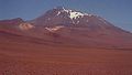
Chile
편집- Monte San Valentin(Monte San Valentin), 4,058 m (13,314 ft)
- Cerro Paine Grande(Cerro Paine Grande), c.2,750 m (9,022 ft)
- Cerro Macá(Cerro Macá), c.2,300 m (7,546 ft)
- Monte Darwin(Monte Darwin), c.2,500 m (8,202 ft)
- Volcan Hudson(Volcan Hudson), c.1,900 m (6,234 ft)
- Cerro Castillo Dynevor(Cerro Castillo Dynevor), c.1,100 m (3,609 ft)
- Mount Tarn(Mount Tarn), c.825 m (2,707 ft)
- Polleras, 5,993 m (19,662 ft)
-

-
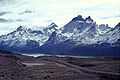
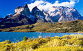 View of Cuernos del Paine in Torres del Paine National Park(Torres del Paine National Park)


Colombia
편집- Nevado del Huila(Nevado del Huila), 5,365 m (17,602 ft)
- Nevado del Ruiz(Nevado del Ruiz), 5,321 m (17,457 ft)
- Nevado del Tolima(Nevado del Tolima), 5,205 m (17,077 ft)
- Pico Pan de Azucar(Pico Pan de Azucar), 5,200 m (17,060 ft)
- Ritacuba Negra(Ritacuba Negra), 5,320 m (17,454 ft)
- Nevado del Cumbal(Nevado del Cumbal), 4,764 m (15,630 ft)
- Cerro Negro de Mayasquer(Cerro Negro de Mayasquer), 4,445 m (14,583 ft)
- Ritacuba Blanco(Ritacuba Blanco), 5,410 m (17,749 ft)
- Nevado del Quindío(Nevado del Quindío), 5,215 m (17,110 ft)
- Purace(Purace), 4,655 m (15,272 ft)
- Santa Isabel(Santa Isabel), 4,955 m (16,257 ft)
- Doña Juana(Doña Juana), 4,150 m (13,615 ft)
- Galeras(Galeras), 4,276 m (14,029 ft)
- Azufral(Azufral). 4,070 m (13,353 ft)
-
-
 Nevado del Ruiz(Nevado del Ruiz), Colombia


Ecuador
편집- Antisana(Antisana), 5,752 m (18,871 ft)
- Cayambe(Cayambe), 5,790 m (18,996 ft)
- 침보라소 산(Chimborazo), 6,268 m (20,564 ft)
- Corazón(Corazón), 4,790 m (15,715 ft)
- Cotopaxi(Cotopaxi), 5,897 m (19,347 ft)
- El Altar(El Altar), 5,320 m (17,454 ft)
- Illiniza(Illiniza), 5,248 m (17,218 ft)
- Pichincha(Pichincha), 4,784 m (15,696 ft)
- Quilotoa(Quilotoa), 3,914 m (12,841 ft)
- Reventador(Reventador), 3,562 m (11,686 ft)
- Sangay(Sangay), 5,230 m (17,159 ft)
- Tungurahua(Tungurahua), 5,023 m (16,480 ft)
- Titicacha(Titicacha), 5,035 m (16,519 ft)


Peru
편집- Alpamayo(Alpamayo), 5,947 m (19,511 ft)
- Artesonraju(Artesonraju), 6,025 m (19,767 ft)
- Carnicero(Carnicero), 5,960 m (19,554 ft)
- El Misti(El Misti), 5,822 m (19,101 ft)
- El Toro(El Toro), 5,830 m (19,127 ft)
- Huandoy(Huandoy), 6,395 m (20,981 ft)
- 우아스카란 산(Huascarán), 6,768 m (22,205 ft)
- Jirishanca(Jirishanca), 6,094 m (19,993 ft)
- Nevado de Huaytapallana(Nevado de Huaytapallana), 5,557 m (18,232 ft)
- Pumasillo(Pumasillo), 5,991 m (19,656 ft)
- Rasac(Rasac), 6,040 m (19,816 ft)
- Rondoy(Rondoy), 5,870 m (19,259 ft)
- Sarapo(Sarapo), 6,127 m (20,102 ft)
- Seria Norte(Seria Norte), 5,860 m (19,226 ft)
- Siula Grande(Siula Grande), 6,344 m (20,814 ft)
- Yerupaja(Yerupaja), 6,635 m (21,768 ft)
- Yerupaja Chico(Yerupaja Chico), 6,089 m (19,977 ft)


Venezuela
편집- 볼리바르 봉(Pico Bolívar), 4,981 m (16,342 ft)
- Pico Humboldt(Pico Humboldt), 4,940 m (16,207 ft)
- Pico Bonpland(Pico Bonpland), 4,880 m (16,010 ft)
- Pico La Concha(Pico La Concha), 4,870 m (15,978 ft)
- Pico Piedras Blancas(Pico Piedras Blancas), 4,740 m (15,551 ft)
-
 볼리바르 봉(Pico Bolívar), Venezuela
 -
 Pico Humboldt(Pico Humboldt), Venezuela


Notes
편집- ↑ 가 나 Andes travel map
- ↑ “Climate of the Andes”. 2007년 12월 9일에 확인함.
- ↑ Jan-Christoph Otto, Joachim Götz, Markus Keuschnig, Ingo Hartmeyer, Dario Trombotto, and Lothar Schrott (2010). Geomorphological and geophysical investigation of a complex rock glacier system - Morenas Coloradas valley (Cordon del Plata, Mendoza, Argentina)
- ↑ 가 나 다 Tropical Andes - biodiversityhotspots.org
- ↑ “Plants of the Andes”. 2007년 12월 9일에 확인함.
- ↑ D'Altroy, Terence N. The Incas. Blackwell Publishing, 2003
See also
편집- Andean Geology(Andean Geology) - a 과학 저널(scientific journal)
- Apu (god)(Apu (god))
- Cordillera Mountains(Cordillera Mountains) in the 필리핀(Philippines)
- Mountain Passes of the Andes(Mountain Passes of the Andes)
References
편집- John Biggar, The Andes: A Guide For Climbers, 3rd. edition, 2005, ISBN 0-9536087-2-7
- Tui de Roy, The Andes: As the Condor Flies. 2005, ISBN 1-55407-070-8
- Fjeldså, J., & N. Krabbe (1990). The Birds of the High Andes. Zoological Museum, University of Copenhagen, Copenhagen. ISBN 87-88757-16-1
- Fjeldså, J. & M. Kessler. 1996. Conserving the biological diversity of Polylepis woodlands of the highlands on Peru and Bolivia, a contribution to sustainable natural resource management in the Andes. NORDECO, Copenhagen.
External links
편집- Andes geology (University of Arizona)
- Climate and animal life of the Andes
- http://www.peaklist.org/WWlists/ultras/southamerica.html Complete list of mountains in South America with a prominence(prominence) of at least 1,500 m (4,920 ft)
영한병기판
편집| Andes (Quechua(케추아어족): Anti(s/kuna)(Anti(s/kuna))) | |
| Range | |
| | |
| 나라 | Argentina · Bolivia · Chile · Colombia · Ecuador · Peru · Venezuela |
|---|---|
| 도시 | Bogotá(보고타) · Santiago(산티아고) · Medellín(메데인) · La Paz(La Paz|라파스) · Cali(Cali|칼리) · Quito(키토) · Pasto(Pasto) · Bucaramanga(Bucaramanga) · Arequipa(아레키파) · Mendoza(멘도사) · Cuenca(Cuenca|쿠엥카) · Cochabamba(코차밤바) · Pereira(페레이라) · Ibagué(Ibagué) · Salta(살타) · Manizales(Manizales) · Cucúta(Cucúta) · Cusco(쿠스코) · Mérida(메리다 (베네수엘라)) · Sucre(수크레) |
| 최고점 | Mt. Aconcagua(아콩카과 산) |
| - 위치 | on the Argentina(아르헨티나)-Chile(칠레) border |
| - 높이 | 6,962 m (22,841 ft) |
| - 좌표 | 남위 32° 39′ 10″ 서경 70° 0′ 40″ / 남위 32.65278° 서경 70.01111° |
| 길이 | 7,000 km (4,350 mi) |
| 폭 | 500 km (311 mi) |
|
Composite satellite image of the southern Andes
| |
The Andes are the world's longest continental(대륙 지각) mountain range(산맥). It is a continual range of highlands along the western coast of South America(남아메리카). This range is about 7,000 km (4,300 mi) long, about 200 km (120 mi) to 700 km (430 mi) wide (widest between 18 degree(도 (각도))s South and 20 degrees South latitude(위도)), and of an average height of about 4,000 m (13,000 ft).
Along their length, the Andes are split into several ranges, which are separated by intermediate depression(depression)s. The Andes are the location of several high plateaus – some of which are the locations of major cities(도시) such as Quito(키토), Bogotá(보고타), Santiago de Chile(산티아고 (칠레)), Medellín(메데인), Sucre(수크레), and La Paz(라파스).
The so-called Altiplano plateau(Altiplano plateau) is probably the second-highest plateau following the Tibetan plateau(Tibetan plateau). The Andes extend to seven countries, in alphabetical order: Argentina(아르헨티나), Bolivia(볼리비아), Chile(칠레), Colombia(콜롬비아), Ecuador(에콰도르), Peru(페루), and Venezuela(베네수엘라), some of which are known as the Andean States(Andean States).
The Andes range is the world's highest mountain range outside of the continent(대륙) of Asia(아시아). Their highest peak, Mt. Aconcagua(아콩카과 산), rises to an elevation of about 6,962 m (22,841 ft) above sea level(해수면). The peak(peak) of Mt. Chimborazo(침보라소 산) in the Ecuadorean Andes is located the point on the surface of the Earth that is the most distant one from its center. This is because of the Earth's equatorial bulge(equatorial bulge) that results from its rapid rotation (far faster than those of Venus(금성), Mercury(머큐리), the Moon(달), Ganymede(가니메데), Titan(티탄), or Triton(트리톤)). The world's highest volcanos are in the Andes, including Ojos del Salado(오호스델살라도 산) on the Chile-Argentina frontier which rises to 6,893 m (22,615 ft), and over 50 other volcanos that rise above 6,000 m.
Name
편집The etymology of the word Andes has been debated. The major consensus is that it derives from the Quechua(케추아어족) word anti, which means "high crest". Others believe that Andes comes Anti Suyu(Anti Suyu), one of the four regions of the Inca empire. It is more likely however that the word Antisuyo derives from the use of Anti to designate mountain chains. Derivation from the Spanish(스페인어) andén (in the sense of cultivation terrace(계단식 논)) has also been proposed, yet considered very unlikely.
Geography
편집 The Andes can be divided into three sections:
I. The Southern Andes in Argentina and Chile;
II. The Central Andes, including the Chilean and Peruvian cordilleras and parts of Bolivia;
III. The Northern Andes in Venezuela, Colombia, and Ecuador that consist of two parallel ranges, the Cordillera Occidental and the Cordillera Oriental. In Colombia, south its the border with Ecuador, the Andes split in three parallel ranges, the western, central, and eastern ranges. (The cordillera occidental, central, and oriental).
In the northern part of the Andes, the isolated Sierra Nevada de Santa Marta(Sierra Nevada de Santa Marta) range is often considered to be part of the Andes. The eastern range of Colombia is the only one that extends to Venezuela.[1] The term cordillera comes from the Spanish word meaning "rope", because Spain does not possess any large mountain ranges. The Andes range is about 200 킬로미터 (124 마일) wide throughout its length, except in the Bolivian flexure where it is about 640 킬로미터 (398 마일) wide. The islands of the Dutch Caribbean Aruba(아루바), Bonaire(보네르 섬), and Curaçao(퀴라소 섬), which lie in the Caribbean Sea(카리브 해) off the coast of Venezuela, represent the submerged peaks of the extreme northern edge of the Andes range.
Geology
편집틀:Geology of the Andes 틀:Expand The Andes are a Mesozoic(중생대) – Tertiary(제3기) orogenic(orogenic) belt of mountains along the Pacific Ring of Fire(환태평양 조산대), a zone of volcanic activity(volcanic activity) that encompasses the Pacific rim of the Americas as well as the Asia-Pacific(아시아 태평양) region. The Andes are the result of plate tectonics(판 구조론) processes, caused by the subduction(섭입) of oceanic crust(해양 지각) beneath the South American plate(South American plate). The main cause of the rise of the Andes is the compression of western rim of the South American Plate(남아메리카판) due to the subduction of the Nazca Plate(나스카판) and the Antarctic Plate(남극판). To the east, the Andes are bounded by several sedimentary basin(퇴적 분지)s such as Orinoco(오리노코 강), Amazon Basin(Amazon Basin), Madre de Dios(Madre de Dios) and Gran Chaco(그란차코) which separates the Andes from the ancient craton(craton)s in eastern South America. In the south the Andes shares a long boundary with the former Patagonia Terrane(파타고니아). To the west the Andes ends at the Pacific Ocean(태평양), although the Peru-Chile trench(Peru-Chile trench) can be considerated its ultimate western limit. From a geographical approach the Andes are considered to have their western boundaries marked by the appearance of coastal lowlands and a less rugged topography.
Orogeny
편집The western rim of the South American Plate(남아메리카판) has been the place of several pre-Andean orogenies since at least the of the late Proterozoic(원생누대) and early Paleozoic(고생대) when several terrane(terrane)s and microcontinent(microcontinent)s collided and amalgamated with the ancient craton(craton)s of eastern South America, by then the South American part(남아메리카판) of Gondwana(곤드와나).
The formation of the modern Andes began with the events of the Triassic(트라이아스기) when Pangea begun to break up and several rift(rift)s developed. It continued through the Jurassic(쥐라기) Period. It was during the Cretaceous(백악기) Period that the Andes began to take their present form, by the uplifting(uplifting), faulting(단층) and folding(습곡) of sedimentary(sedimentary) and metamorphic rocks(metamorphic rocks) of the ancient craton(craton)s to the east. The rise of the Andes has not been been constant and different regions have had different degrees of tectonic stress, uplift, and erosion(침식).
Tectonic forces above the subduction zone(subduction zone) along the entire west coast of South America where the Nazca Plate(나스카판) and a part of the Antarctic Plate(남극판) are sliding beneath the South American Plate(남아메리카판) continue to produce an ongoing orogenic event(조산 운동) resulting in minor to major earthquake(지진)s and volcanic eruption(volcanic eruption)s to this day. In the extreme south a major transform fault(변환 단층) separates Tierra del Fuego(티에라델푸에고 제도) from the small Scotia Plate(스코티아판). Across the 1,000 km (620 mi) wide Drake Passage(드레이크 해협) lie the mountains of the Antarctic Peninsula(남극 반도) south of the Scotia Plate which appear to be a continuation of the Andes chain.[출처 필요]
Volcanism
편집 The Andes range has many active volcanoes, which are distributed in four volcanic zones separated by areas of inactivity. The Andean volcanism is a result of subduction(섭입) of the Nazca Plate(나스카판) and Antarctic Plate(남극판) underneath the South American Plate(남아메리카판). The belt is subdivided into four main volcanic zones that are separed from each other by volcanic gaps. The volcanoes of the belt are diverse in terms of activity style, products and morphology. While some differences can be explained by which volcanic zone a volcano belongs to, there significant differences inside volcanic zones and even between neighboring volcanoes. Despite being a type location for calc-alkalic(calc-alkalic) and subduction volcanism, the Andean Volcanic Belt has a large range of volcano-tectonic settings, such as rift systems and extrensional zones, transpressional faults, subduction of mid-ocean ridge(해령)s and seamount(seamount) chains apart from a large range on crustal thicknesses and magma(마그마) ascent paths, and different amount of crustal assimilations.
Ore deposits and evaporites
편집Climate and hydrology
편집 The climate in the Andes varies greatly depending on location, altitude, and proximity to the sea. The southern section is rainy and cool, the central Andes are dry. The northern Andes are typically rainy and warm, with an average temperature of 18 °C (64 °F) in Colombia. The climate is known to change drastically in rather short distances. Rainforest(우림)s exist just miles away from the snow covered peak Cotopaxi. The mountains have a large effect on the temperatures of nearby areas. The snow line(snow line) depends on the location. It is at between 4,500–4,800 m (14,800–15,800 ft) in the tropical Ecuadorian, Colombian, Venezuelan, and northern Peruvian Andes, rising to 4,800–5,200 m (15,800–17,060 ft) in the drier mountains of southern Peru south to northern Chile south to about 30°S, then descending to 4,500 m (14,760 ft) on Aconcagua at 32°S, 2,000 m (6,600 ft) at 40°S, 500 m (1,640 ft) at 50°S, and only 300 m (980 ft) in Tierra del Fuego(티에라델푸에고 제도) at 55°S; from 50°S, several of the larger glaciers descend to sea level.[2]
The Andes of Chile and Argentina can be divided in two climatic and glaciological zones; the Dry Andes(Dry Andes) and the Wet Andes(Wet Andes). Since the Dry Andes extends from the latitudes of Atacama Desert(아타카마 사막) to the area of Maule River(Maule River), precipitation is more sporadical and there are strong temperature oscillations. The line of equilibrium may shift drastically over short periods of time, leaving a whole glacier in the ablation(ablation) area or in the accumulation area(accumulation area).
In the high Andes of central Chile and Mendoza Province(멘도사 주) rock glacier(rock glacier)s are larger and more common than glaciers, this is due to the high exposure to solar radiation(solar radiation).[3]
Flora
편집Rainforests(Rainforests) used to encircle much of the northern Andes but are now greatly diminished(Deforestation), especially in the Chocó(Chocó) and inter-Andean valleys of Colombia. As a direct opposite of the humid Andean slopes are the relatively dry Andean slopes in most of western Peru, Chile and Argentina. Along with several Interandean Valles(Interandean Valles), they are typically dominated by deciduous(낙엽성) woodland, shrub and xeric(xeric) vegetation, reaching the extreme in the slopes near the virtually lifeless Atacama Desert.
About 30,000 species of vascular plants(vascular plants) live in the Andes with roughly half being endemic(고유종) to the region, surpassing the diversity of any other hotspot(hotspot|핫스팟).[4] The small tree Cinchona pubescens(Cinchona pubescens), a source of quinine(퀴닌) which is used to treat malaria(말라리아), is found widely in the Andes as far south as Bolivia. Other important crops that originated from the Andes are tobacco(담배 (식물)) and potatoes(potatoes). The high-altitude Polylepis(Polylepis) forests and woodlands are found in the Andean areas of Colombia, Ecuador, Peru, Bolivia and Chile. These trees, by locals referred to as Queñua, Yagual and other names, can be found at altitudes of 4,500 m (14,760 ft) above sea level. It remains unclear if the patchy distribution of these forests and woodlands is natural, or the result of clearing which began during the Inca(Inca)n period. Regardless, in modern times(modern times) the clearance has accelerated, and the trees are now considered to be highly endangered(endangered), with some believing that as little as 10% of the original woodland remains.[5]
Fauna
편집 The Andes are rich in fauna: With almost 1,000 species, of which roughly 2/3 are endemic(endemic]]) to the region, the Andes are the most important region in the world for amphibians(amphibians).[4] The diversity of animals in the Andes is high, with almost 600 species of mammals(mammals) (13% endemic), more than 1,700 species of birds(birds) (about 1/3 endemic), more than 600 species of reptiles(reptiles) (about 45% endemic), and almost 400 species of fish(물고기) (about 1/3 endemic).[4]
The Vicuña(비쿠냐) and Guanaco(구아나코) can be found living in the Altiplano(Altiplano), while the closely related domesticated(domesticated) Llama(라마) and Alpaca(알파카) are widely kept by locals as pack animal(pack animal)s and for their meat(고기) and wool(양모). The nocturnal chinchilla(chinchilla)s, two threatened members of the rodent(설치류) order, inhabits the Andes' alpine regions. The Andean Condor(Andean Condor), the largest bird of its kind in the Western Hemisphere(서반구), occurs throughout much of the Andes but generally in very low densities. Other animals found in the relatively open habitats of the high Andes include the huemul(huemul), cougar(퓨마), foxes in the genus Pseudalopex(Pseudalopex), and, for birds, certain species of tinamou(도요타조)s (notably members of the genus Nothoprocta(Nothoprocta)), Andean Goose(Andean Goose), Giant Coot(Giant Coot), flamingo(홍학)s (mainly associated with hypersaline(hypersaline) lakes), Lesser Rhea(Lesser Rhea), Andean Flicker(Andean Flicker), Diademed Sandpiper-plover(Diademed Sandpiper-plover), miners(miners), sierra-finches(sierra-finches) and diuca-finches(diuca-finches).
Lake Titicaca(티티카카 호) hosts several endemics, among them the highly endangered Titicaca Flightless Grebe(Titicaca Flightless Grebe) and Titicaca Water Frog(Titicaca Water Frog). A few species of hummingbirds(hummingbirds), notably some hillstars(hillstars), can be seen at altitudes above 4,000 m (13,100 ft), but far higher diversities(diversities) can be found at lower altitudes, especially in the humid Andean forests ("cloud forest(cloud forest)s") growing on slopes in Colombia, Ecuador, Peru, Bolivia and far northwestern Argentina. These forest-types, which includes the Yungas(Yungas) and parts of the Chocó, are very rich in flora and fauna, although few large mammals exists, exceptions being the threatened Mountain Tapir(산악맥), Spectacled Bear(안경곰) and Yellow-tailed Woolly Monkey(노랑꼬리양털원숭이).
Birds of humid Andean forests include mountain-toucan(mountain-toucan)s, quetzal(quetzal)s and the Andean Cock-of-the-rock(Andean Cock-of-the-rock), while mixed species flock(mixed species flock)s dominated by tanagers(tanagers) and Furnariids(Furnariids) commonly are seen - in contrast to several vocal but typically cryptic(보호색) species of wrens(wrens), tapaculo(tapaculo)s and antpitta(antpitta)s.
A number of species such as the Royal Cinclodes(Royal Cinclodes) and White-browed Tit-spinetail(White-browed Tit-spinetail) are associated with Polylepis, and consequently also threatened(threatened).
Human activity
편집이 문서는 위키백과의 편집 지침에 맞춰 다듬어야 합니다. |
The Andes mountains form a north-south axis of cultural influences. A long series of cultural development culminated in the expansion of the Inca civilization(잉카 문명) and Inca Empire(잉카 문명) in the central Andes during the 15th century. The Incas formed this civilization through imperialistic militarism as well as careful and meticulous governmental management.[6] The government sponsored the construction of aqueducts(aqueducts) and roads(roads) in addition to preexisting installations. Some of these constructions are still in existence today.
Devastated by European diseases to which they had no immunity(immunity), and civil wars, in 1532 the Incas were defeated by an alliance composed of tens of thousands allies from nations they had subjugated (e.g. Huancas(Huancas), Chachapoyas(Chachapoyas), Cañaris(Cañaris)) and a small army of 180 Spaniards led by Francisco Pizarro(프란시스코 피사로). One of the few Inca sites the Spanish never found in their conquest was Machu Picchu(마추 픽추), which lay hidden on a peak on the eastern edge of the Andes where they descend to the Amazon. The main surviving languages of the Andean peoples are those of the Quechua(케추아어족) and Aymara language(아이마라어) families. Woodbine Parish(Woodbine Parish) and Joseph Barclay Pentland(Joseph Barclay Pentland) surveyed a large part of the Bolivian Andes from 1826 to 1827.
In modern times, the largest Andean cities are Bogota, Colombia(Bogota, Colombia), with a population of about eight million, La Paz, Bolivia(La Paz, Bolivia), and Quito, Ecuador(Quito, Ecuador).
Transportation
편집Several major cities exist either in the Andes or in their foothills, among which are Bogotá(보고타) and Cali, Colombia(Cali, Colombia), Quito, Ecuador(Quito, Ecuador), Mérida, Venezuela(Mérida, Venezuela), La Paz, Bolivia(La Paz, Bolivia), Santiago, Chile(산티아고 (칠레)), and Cusco, Peru(Cusco, Peru). These and most other cities and large towns are now connected with asphalt(아스팔트 콘트리트)-paved roads, while smaller towns are often connected by dirt roads, which may require a four-wheel-drive(four-wheel-drive) vehicle.[1]
Highway(Highway)s and railroad(railroad)s that cross the Andes are quite rare, even with modern civil engineering(토목공학) practices. For example, there is not one highway that crosses over the Andes between Argentina and Chile, though the ends of some highways come rather close to one another from the east and the west. By using tunnels, etc., there are one or two railroads that connect Argentina and Chile. Much of the transportation of passengers is done via airline(항공사).
It is curious that for decades, Chile claimed ownership of land on the eastern side of the Andes. However, these claims were given up in about 1870 during the War of the Pacific(태평양 전쟁 (남아메리카)) between Chile, and the allied Bolivia and Peru, in a diplomatic deal to keep Argentina out of the war. The Chilean Army(Chilean Army) and Chilean Navy(Chilean Navy) defeated the combined forces of Bolivia and Peru, and Chile took over Bolivia's only province on the Pacific Coast, and some land from Peru, also - that was returned to Peru later. Bolivia has been a landlocked(landlocked) country ever since then.
However, if Chile had kept some land to its the east, the difficulties in transportation between east and west would have been enormous. There has also been bad blood between Bolivia and Chile ever since 1870, and these two countries have not had diplomatic relations since about 1974.
Because of the tortuous terrain in places, villages and towns in which motorized vehicle(motorized vehicle)s are of little use are still present. Locally, the relatives of the camel(낙타), the llama(라마) and the alpaca(알파카) continue to carry out important uses as pack animals, but this use has generally diminished into modern times.
Agriculture
편집 The ancient peoples of the Andes such as the Incas have practiced irrigation(관개) techniques for over 6,000 years. Because of the mountain slopes, terracing(계단식 논) has been a common practice. Terracing, however, was only extensively employed after Incan imperial expansions to fuel their expanding realm. The potato(감자) holds a very important role as an internally consumed staple crop. Maize(옥수수) was also an important crop for these people. However, they were mainly used for the production of the culturally important chicha(치차). Currently, tobacco(담배 (식물)), cotton(목화) and coffee(커피) are the main export crops. Coca(코카나무), despite eradication programmes in some countries, remains an important crop for legal local use in a mildly stimulating herbal tea(허브차), and, both controversially and illegally, for the production of cocaine(코카인).
Mining
편집The Andes rose to fame for its mineral wealth during the Spanish conquest of South America(Spanish conquest of South America). Although Andean Amerindian peoples crafted ceremonial jewelry of gold and other metals the mineralization(mineralization)s of the Andes were first mined in large scale after the Spanish arrival. Potosí(포토시) in present-day Bolivia(볼리비아) was one of the principal mines of the Spanish Empire in the New World. Río de la Plata(라플라타 강) and Argentina(아르헨티나) derive their names from the silver of Potosí.
Currently, mining in the Andes of Chile(칠레) and Peru(페루) place these countries as the 1st and 3rd major producers of copper(구리) in the world. The Bolivian Andes produce principally tin(주석 (원소)) although historically silver mining had a huge impact on the economy(economy|경제) of 17th century Europe.
There is a long history of mining in the Andes, from the Spanish silver(은) mine(mine]])s in Potosí(포토시) in the 16th century to the vast current porphyry copper deposit(porphyry copper deposit)s of Chuquicamata(Chuquicamata) and Escondida(Escondida) in Chile and Toquepala(Toquepala) in Peru. Other metals including iron, gold and tin in addition to non-metallic resources are also important.
Peaks
편집This list contains some of the major peaks in the Andes mountain range. The highest peak is Aconcagua of Argentina (see below).
Argentina
편집- Aconcagua(아콩카과 산), 6,962 m (22,841 ft)
- Cerro Bonete(Cerro Bonete), 6,759 m (22,175 ft)
- Galán(Galán), 5,912 m (19,396 ft)
- Mercedario(Mercedario), 6,720 m (22,047 ft)
- Pissis(Pissis), 6,795 m (22,293 ft)
Border between Argentina and Chile
편집- Cerro Bayo(Cerro Bayo), 5,401 m (17,720 ft)
- Cerro Chaltén(Cerro Chaltén), 3,375 m (11,073 ft) or 3,405 m, Patagonia(파타고니아), also known as Cerro Fitz Roy
- Cerro Escorial(Cerro Escorial), 5,447 m (17,871 ft)
- Cordón del Azufre(Cordón del Azufre), 5,463 m (17,923 ft)
- Falso Azufre(Falso Azufre), 5,890 m (19,324 ft)
- Incahuasi(Incahuasi), 6,620 m (21,719 ft)
- Lastarria(Lastarria), 5,697 m (18,691 ft)
- Llullaillaco(Llullaillaco), 6,739 m (22,110 ft)
- Maipo(Maipo), 5,264 m (17,270 ft)
- Marmolejo(Marmolejo), 6,110 m (20,046 ft)
- Ojos del Salado(오호스델살라도 산), 6,893 m (22,615 ft)
- Olca(Olca), 5,407 m (17,740 ft)
- Sierra Nevada de Lagunas Bravas(Sierra Nevada de Lagunas Bravas), 6,127 m (20,102 ft)
- Socompa(Socompa), 6,051 m (19,852 ft)
- Nevado Tres Cruces(Nevado Tres Cruces), 6,749 m (south summit) (III Region)
- Tronador(Tronador), 3,491 m (11,453 ft)
- Tupungato(Tupungato), 6,570 m (21,555 ft)
- Nacimiento(Nacimiento), 6,492 m (21,299 ft)
-
-
Llullaillaco(Llullaillaco), Argentina/Chile -
Camino de Alta Montaña, Argentina/Chile
Bolivia
편집- Ancohuma(Ancohuma), 6,427 m (21,086 ft)
- Cabaray(Cabaray), 5,860 m (19,226 ft)
- Chacaltaya(Chacaltaya), 5,421 m (17,785 ft)
- Huayna Potosí(Huayna Potosí), 6,088 m (19,974 ft)
- Illampu(Illampu), 6,368 m (20,892 ft)
- Illimani(Illimani), 6,438 m (21,122 ft)
- Macizo de Larancagua(Macizo de Larancagua), 5,520 m (18,110 ft)
- Macizo de Pacuni(Macizo de Pacuni), 5,400 m (17,720 ft)
- Nevado Anallajsi(Nevado Anallajsi), 5,750 m (18,865 ft)
- Nevado Sajama(사하마 산), 6,542 m (21,463 ft)
- Patilla Pata(Patilla Pata), 5,300 m (17,390 ft)
- Tata Sabaya(Tata Sabaya), 5,430 m (17,815 ft)
Border between Bolivia and Chile
편집- Acotango(Acotango), 6,052 m (19,856 ft)
- Cerro Minchincha(Cerro Minchincha), 5,305 m (17,405 ft)
- Irruputuncu(Irruputuncu), 5,163 m (16,939 ft)
- Licancabur(Licancabur), 5,920 m (19,423 ft)
- Olca(Olca), 5,407 m (17,740 ft)
- Parinacota(Parinacota), 6,348 m (20,827 ft)
- Paruma(Paruma), 5,420 m (17,782 ft)
- Pomerape(Pomerape), 6,282 m (20,610 ft)
-
Licancabur(Licancabur), Bolivia/Chile
-
Chile
편집- Monte San Valentin(Monte San Valentin), 4,058 m (13,314 ft)
- Cerro Paine Grande(Cerro Paine Grande), c.2,750 m (9,022 ft)
- Cerro Macá(Cerro Macá), c.2,300 m (7,546 ft)
- Monte Darwin(Monte Darwin), c.2,500 m (8,202 ft)
- Volcan Hudson(Volcan Hudson), c.1,900 m (6,234 ft)
- Cerro Castillo Dynevor(Cerro Castillo Dynevor), c.1,100 m (3,609 ft)
- Mount Tarn(Mount Tarn), c.825 m (2,707 ft)
- Polleras, 5,993 m (19,662 ft)
-
-
View of Cuernos del Paine in Torres del Paine National Park(Torres del Paine National Park)
Colombia
편집- Nevado del Huila(Nevado del Huila), 5,365 m (17,602 ft)
- Nevado del Ruiz(Nevado del Ruiz), 5,321 m (17,457 ft)
- Nevado del Tolima(Nevado del Tolima), 5,205 m (17,077 ft)
- Pico Pan de Azucar(Pico Pan de Azucar), 5,200 m (17,060 ft)
- Ritacuba Negra(Ritacuba Negra), 5,320 m (17,454 ft)
- Nevado del Cumbal(Nevado del Cumbal), 4,764 m (15,630 ft)
- Cerro Negro de Mayasquer(Cerro Negro de Mayasquer), 4,445 m (14,583 ft)
- Ritacuba Blanco(Ritacuba Blanco), 5,410 m (17,749 ft)
- Nevado del Quindío(Nevado del Quindío), 5,215 m (17,110 ft)
- Purace(Purace), 4,655 m (15,272 ft)
- Santa Isabel(Santa Isabel), 4,955 m (16,257 ft)
- Doña Juana(Doña Juana), 4,150 m (13,615 ft)
- Galeras(Galeras), 4,276 m (14,029 ft)
- Azufral(Azufral). 4,070 m (13,353 ft)
-
-
Nevado del Ruiz(Nevado del Ruiz), Colombia
Ecuador
편집- Antisana(Antisana), 5,752 m (18,871 ft)
- Cayambe(Cayambe), 5,790 m (18,996 ft)
- Chimborazo(침보라소 산), 6,268 m (20,564 ft)
- Corazón(Corazón), 4,790 m (15,715 ft)
- Cotopaxi(Cotopaxi), 5,897 m (19,347 ft)
- El Altar(El Altar), 5,320 m (17,454 ft)
- Illiniza(Illiniza), 5,248 m (17,218 ft)
- Pichincha(Pichincha), 4,784 m (15,696 ft)
- Quilotoa(Quilotoa), 3,914 m (12,841 ft)
- Reventador(Reventador), 3,562 m (11,686 ft)
- Sangay(Sangay), 5,230 m (17,159 ft)
- Tungurahua(Tungurahua), 5,023 m (16,480 ft)
- Titicacha(Titicacha), 5,035 m (16,519 ft)
Peru
편집- Alpamayo(Alpamayo), 5,947 m (19,511 ft)
- Artesonraju(Artesonraju), 6,025 m (19,767 ft)
- Carnicero(Carnicero), 5,960 m (19,554 ft)
- El Misti(El Misti), 5,822 m (19,101 ft)
- El Toro(El Toro), 5,830 m (19,127 ft)
- Huandoy(Huandoy), 6,395 m (20,981 ft)
- Huascarán(우아스카란 산), 6,768 m (22,205 ft)
- Jirishanca(Jirishanca), 6,094 m (19,993 ft)
- Nevado de Huaytapallana(Nevado de Huaytapallana), 5,557 m (18,232 ft)
- Pumasillo(Pumasillo), 5,991 m (19,656 ft)
- Rasac(Rasac), 6,040 m (19,816 ft)
- Rondoy(Rondoy), 5,870 m (19,259 ft)
- Sarapo(Sarapo), 6,127 m (20,102 ft)
- Seria Norte(Seria Norte), 5,860 m (19,226 ft)
- Siula Grande(Siula Grande), 6,344 m (20,814 ft)
- Yerupaja(Yerupaja), 6,635 m (21,768 ft)
- Yerupaja Chico(Yerupaja Chico), 6,089 m (19,977 ft)


Venezuela
편집- Pico Bolívar(볼리바르 봉), 4,981 m (16,342 ft)
- Pico Humboldt(Pico Humboldt), 4,940 m (16,207 ft)
- Pico Bonpland(Pico Bonpland), 4,880 m (16,010 ft)
- Pico La Concha(Pico La Concha), 4,870 m (15,978 ft)
- Pico Piedras Blancas(Pico Piedras Blancas), 4,740 m (15,551 ft)
-
Pico Bolívar(볼리바르 봉), Venezuela
-
Pico Humboldt(Pico Humboldt), Venezuela
Notes
편집- ↑ 가 나 Andes travel map
- ↑ “Climate of the Andes”. 2007년 12월 9일에 확인함.
- ↑ Jan-Christoph Otto, Joachim Götz, Markus Keuschnig, Ingo Hartmeyer, Dario Trombotto, and Lothar Schrott (2010). Geomorphological and geophysical investigation of a complex rock glacier system - Morenas Coloradas valley (Cordon del Plata, Mendoza, Argentina)
- ↑ 가 나 다 Tropical Andes - biodiversityhotspots.org
- ↑ “Plants of the Andes”. 2007년 12월 9일에 확인함.
- ↑ D'Altroy, Terence N. The Incas. Blackwell Publishing, 2003
See also
편집- Andean Geology(Andean Geology) - a scientific journal(과학 저널)
- Apu (god)(Apu (god))
- Cordillera Mountains(Cordillera Mountains) in the Philippines(필리핀)
- Mountain Passes of the Andes(Mountain Passes of the Andes)
References
편집- John Biggar, The Andes: A Guide For Climbers, 3rd. edition, 2005, ISBN 0-9536087-2-7
- Tui de Roy, The Andes: As the Condor Flies. 2005, ISBN 1-55407-070-8
- Fjeldså, J., & N. Krabbe (1990). The Birds of the High Andes. Zoological Museum, University of Copenhagen, Copenhagen. ISBN 87-88757-16-1
- Fjeldså, J. & M. Kessler. 1996. Conserving the biological diversity of Polylepis woodlands of the highlands on Peru and Bolivia, a contribution to sustainable natural resource management in the Andes. NORDECO, Copenhagen.
External links
편집- Andes geology (University of Arizona)
- Climate and animal life of the Andes
- http://www.peaklist.org/WWlists/ultras/southamerica.html Complete list of mountains in South America with a prominence(prominence) of at least 1,500 m (4,920 ft)
틀:Geography topics 틀:Physical geography topics
- Mountain ranges of South America
- Biodiversity hotspots
- Regions of South America
- Volcanic arcs
- Physiographic divisions
- Mountain ranges of Bolivia
- Mountain ranges of Chile
- Mountain ranges of Peru
- Andes
- Mountain ranges of South America
- Biodiversity hotspots
- Regions of South America
- Volcanic arcs
- Physiographic divisions
- Mountain ranges of Bolivia
- Mountain ranges of Chile
- Mountain ranges of Peru
- Andes